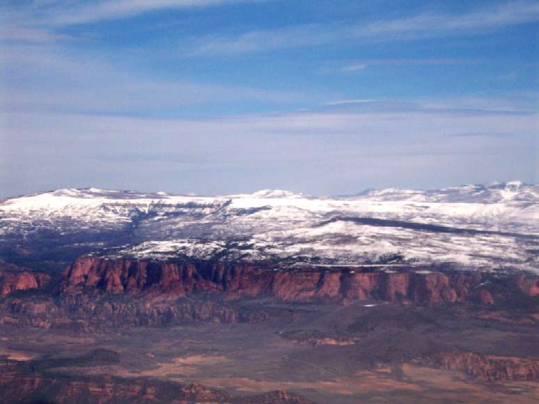
Dave’s Aerial Photos of Zion National Park

I did a lot of traveling around the country in 2002 on what I called an “early semi-retirement”. Of all the places I’ve been in this great country (and a few others), Zion National Park in southwest Utah is, in my opinion, one of the most beautiful places on earth – and yet it is virtually unknown outside the state. Maybe it is dwarfed by the Grand Canyon right next door, or perhaps the Mormons just want to keep it to themselves. A year of my college education was in southern Utah, and many of my weekends were spent in Zion, hiking its trails and taking in its scenery – but in my youthful exuberance I never took any pictures of it. Although it is widely photographed, I decided late last year that it was time to go back, and put my pilot’s license to use to take some truly unique photographs of Zion – this time, from the sky.

To do this, I drove north from Las Vegas to the city of St. George, Utah (elev. 2,941ft) and rented a Cessna 172R from one of the FBOs at the KSGU airport last Sunday. The 10,000 foot climbout seemed to take forever, and I arrived at cruise altitude just about the time I reached the park. I took them from between 12,000 and 13,000 feet above sea level, but I don’t think it was much more than 4 or 5,000 feet above the terrain. Even if you’ve seen photos of Zion before, I think you may get a new perspective on the park after seeing them, particularly at just how vast it really is. Click the image below to go to the gallery.

Posted in Blog, Photos | Leave a comment

It’s Official – Pilot’s License Finished!

After two years of arduous and costly training and the last several months of fighting with weather, schedule coordination, finances, instructors, and paperwork, I finally completed my checkride Tuesday and am now a licensed private pilot.

After putting in a half day at work from 6:30-10:30 Tuesday morning, I went to the airport to have my fate decided.  It lasted from 11:00a until 4:00p and was by far the most grueling, stressful examination of my life.  I wouldn’t wish it on anyone. 

The physical and mental exhaustion I felt on Tuesday eventually gave way to the elation that comes with the accomplishment of being among that most rarified group of people who are licensed to fly.

Posted in Blog, Flying | Leave a comment

Pilot License Phase 2 of 4 complete – Written Exam

After doing a mock checkride examination (flight proficiency demonstration) with another instructor last weekend (phase 1) and doing very well on it, I went ahead with my written examination last night. This is a computerized test administered under video surveillance and has its questions downloaded for each student from a large bank of questions at some distant headquarters. It was 62 questions long and you get two and a half hours to complete it. Here are some examples.

If the empty weight of a plane is 1800lbs, you have 380 lbs of people and 30 gallons fuel with the listed arms for each, how far aft of datum is the aircraft’s center of gravity, and is it within specifications?

You are flying from airport A to airport B on the attached sectional chart, which is 45 nautical miles at a 224 degree heading. Winds aloft at 3000ft are 030 at 22 knots and the true airspeed of your plane is 95 knots. Measure the distance and calculate how long it will take, assuming 2 minutes for climb-out.

You are flying to an airport with runways 8 and 26 with calm winds. The airport facility directory for this airport states that when the winds are calm, a left traffic pattern to runway 8 is the standard approach. There are no other aircraft in the area and a thunderstorm is 6 miles to the west of the airport in the mature stage, with light rain beginning at the airport. Which runway would you choose?

When an unstable air mass is forced upward, what types of clouds and meteorological activity can you expect?

If the gross weight of your aircraft is 2800lbs, the airport elevation is 10,000 feet, temperature is 15C, and altimeter is 29.81, calculate the landing distance required.

After two hours of that I’d had enough. I went back over all my answers and double-checked the ones I wasn’t sure about, and finished it up. I went downstairs to hear my fate.

I saw the indicator on the screen that said I’d passed, which was the relief part, but then on the printout it showed my score: 92%. That was the elation part. I guess taking all those practice tests really paid off. Whew!

Posted in Blog, Flying | Leave a comment

Long-distance Solo Flight to Oshkosh

This time I had my nice new digital camera to take with me, and what a beautiful day it was. Cold, but with clear blue skies, calm winds, and a good 30 miles of visibility. By cold I mean temps near zero.

So the goal today was to do a multi-leg flight to two airports more than 50 miles away. The first, Madison/Truax, I’d done before. It’s a semi-busy class-C airport in Wisconsin’s state capitol. Class C means that it is the 2nd-largest and 2nd-busiest classification of airport, next to class B which is reserved for the nation’s largest and busiest like O’Hare, Kennedy, LAX Los Angeles, McCarran Las Vegas. It also means that it’s complex and challenging, because you have to talk to approach control, tower, ground ops, clearance delivery, and departure control through the duration of your time in their airspace, and are under mandatory terminal radar service control – meaning I am on an ATC radar screen and being given strict directions to follow. Getting there is pretty easy, I just fly out over Lake Geneva to Victor Airway V191, pick up the VOR intercept and fly the Madison VOR at a 320 heading straight to the field. It’s a 78 nautical-mile (90mi) flight and it took me 45 minutes with my ground speed around 120mph. To drive it, it’s 125 miles on I-94 via Milwaukee. I landed gracefully on runway 32 and requested taxi to an FBO, to make it an official full-stop arrival.

So after being directed into a parking spot by a ground worker, I drove past a large private business jet and parked next to a Cirrus SR-20 and an old Mooney. I shut down the plane and took a brief break at the Fixed-Base-Operator (FBO) station there, a beautiful place called Wisconsin Aviation just off the main taxiway. It’s a place you’d never know existed if you weren’t a pilot, one of our special privileges I guess you could say. It’s a luxurious clubhouse, with 25-ft vaulted ceilings and a hanging chandelier over the living room with large, plush navy-blue sofas placed before a lage stone-hearthed fireplace. It’s basically the nicest gas station you’ll ever see this side of Beverly Hills. They offer fuel and mechanical services for aircraft.

So after doing some brief calculations of fuel-on-board and ETAs, I called up Flight Service and filed my flight plan for the next leg of my flight. It was to a regional class-D airport just west of Green Bay in Oshkosh, WI. This is the airport where, every summer, a massive fly-in of about thirty thousand aircraft of every imaginable type takes place for the EAA (Experimental Aircraft Association) annual bash. It’s pretty much the biggest event of its kind in all of aviation. I’ve wanted to go for the past two years, but now that I know how to get there, I can definitely fly in for it this summer.

But the trip up there today was uneventful and quiet. The 61nm (70mi) flight took me 39 minutes. A few other planes were arriving as I was and the tower sequenced us, but it was slow enough that the tower controller was also running ground operations. I landed on runway 9 and taxied off to the FBO there, then hopped out for a few minutes to stretch my legs and do the flight plan for the return trip, the longest of the three.

The return trip from Oshkosh back to Waukegan, based on how I planned it to avoid Milwaukee’s airspace, was 108nm (124mi), basically going straight south until I was due east of Kenosha airport and clear of its airspace, then turning to the southeast for the last 20 miles. With the 16mph tailwind, I expected to make great time getting back. I picked 5500ft for my altitude, and the air was smooth and the skies were clear the whole way until I got 10 miles out from Waukegan. Suddenly I faced a wall of clouds down to 3000ft below me rolling in off Lake Michigan, with dramatically reduced visibility over the entire area. I pulled back on the throttle and started a 1500 feet-per-minute rapid descent to get below the thick cloud layer, and dialed up the terminal weather frequency for Waukegan to find out what was going on. Apparently the bad weather that had plagued O’Hare all morning had moved north while I was gone, though it fortunately didn’t bring the snow with it. The broken ceiling was only down to 2700ft, so 53 minutes after taking off from Oshkosh I landed at Waukegan, with my ground speed averaging around 132kts (151mph) for the last leg of the trip.

Pics and videos I shot of the trip here:

http://www.davedonovan.org/pics/flight021504/small/

Posted in Blog, Flying | Leave a comment